On a recent day I parked at Foster Falls, which is at the approximate halfway point of the trail. This area is easy to access off of I-77 (exit 24), has plenty of parking, a gift shop to buy snacks and drinks and campsites.
From Foster Falls I headed south towards Fries. About 1.2 miles from Foster Falls is Shot Tower State Park.
 |
| View of Shot Tower from Trail |
Not too far down the trail you will get to Austinville, where you will see the remnants of an old lead processing facility. The smoke stacks that were there a few years ago are gone now, but the large empty field next to the river is an eeiry indicator that something used to be there. There is an old structure next to the tracks that was used for loading / unloading the trains. If you jump off the trail at this point and ride down Store Hill Road about 1/4 mile you will see a memorial flying a Texas state flag along with a Virginia state flag and US flag. This is a memorial to Stephen F. Austin, the father of Texas. He was born in this area, and his family ran the lead mining / processing operations before they moved west.
Continuing south on the trail you will pas through a railroad tunnel and across several railroad bridges as you ride along the New River.
In Ivanhoe you can see some cool industrial artifacts, including the Allis Chalmers Co. turbine looking thing in the picture below.
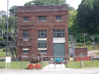
I think this turbine came out of the hydro-electric plant at Buck Dam, which is a liitle farther down the trail. Past the Buck Dam you will see Byllesby Dam, with an even larger hydro electric plant. This one, seen in the picture below, appears to be operational.
Two and a half miles past Byllesby Dam you reach a fork in the trail, at Fries Junction. If you bear to the left, across the bridge in the picture below, you will go to Galax. On this trip I took the trail to the right and rode on to Fries (pronounced freeze, as the lady in the convenience store corrected me). It is 5.5 miles from Fries Junction to Fries.
At Fries I found the only store along the ride.This was at the Blue Cat on the New (bluecat). This was a oasis on the trail, convenience store with full grill. Has a really cool deck overlooking the New River. I bought some oatmeal cream pies and mountain dew here and ate it on the deck, watching the folks tubing the river scramble to their cars as the thunderstorm approached.
I finished my snack and got back on my bike and peddled back to Foster Falls. The first 18 miles back was in a severe thunderstorm. Every few miles there is some sort of shelter where I would stop and catch my breath. The last 6 miles were fairly peaceful.
If you get a chance to ride the New River Trail I strongly encourage you to do so.


No comments:
Post a Comment